Walks
Walks in and around Wensleydale
Askrigg to Mill Gill Circular
Distance: 3 1/2 miles (5.63km)
The walk starts at the church at the west of Askrigg. Follow the down road as you pass over the bridge. Immediately turn left down the left-side the beck to enter a woodland. Continue straight-ahead on path sign-post, ?Mill Gill only? to reach the falls.
Return to the path that leads up the side of the wood. At the top left corner, leave the wood. Go straight-ahead following the footpath sign for Helm, passing through fields to emerge on a road. Turn right up the road to emerge in Helm.
Reach the guesthouse in Helm. Turn right on the path to climb through fields to reach the gill.
When you reach the gill. Keep to left-hand of the gill and go up a path as you continue up it towards a footbridge and Whitefield Gill Force.
Go over the footbridge and go steeply up the other the other side of the gill to reach Low Straights Lane. Continue along this lane for about 1 mile until just before a ford. Turn right here passing a gate and head straight down through fields. Pass through two gate stiles as path eventually bears left to reach the next corner of the field to a smaller stile. From this stile, bear left at a barn with arched doorway. Continue on this path that leads back to village to village of Askrigg, emerging next to the Crown Inn in Askrigg where the walk concludes and finishes.
Aysgarth Falls Circular Walk
Distance: 1.86 miles (3km)
A three kilometre low level walk through Freeholders and St Joseph's Woods taking in the Lower and Middle Falls. The walk starts and finishes at the Aysgarth Falls National Park Centre car park.
From the entrance of the car park the route passes under the railway bridge, past the entrance to the former Aysgarth railway station and on into Freeholders Wood. An area of semi natural woodland owned and managed as a coppice with standards by the National Park Authority with the help of volunteers. The woodland is a Site of Special Scientific Interest and is home to a wide range of plants animals. Once through the wood the route crosses open pastureland and then returns under the railway bridge to St Joseph?s Wood, a new native 15-hectare broadleaf woodland planted in 1998. The route returns through the centre of Freeholders Wood to the start of the Millennium Trail. A surfaced trail leading to the Lower and Middle Falls viewing platforms through the woodland and along Riddings Field, passing four interpretative art works. Upon reaching the Lower Falls, the route then returns to the National Park Centre via the Millennium Trail.
Interpretation and leaflets are available within the National Park Centre explaining the important features of the woodland, river and falls.
To visit the Upper Falls, follow the path around the edge of the car park and follow the path down to the entrance. Please note that the Upper Falls is private land and an admission charge is made by way of an honesty box for providing access.
Aysgarth Falls and Bolton Castle
Distance: 7 miles (11.27km)
Start at Aysgarth Falls National Park Visitor Centre. From the visitor centre, turn right along the path to the Middle and Lower Falls. Cross over the road and go straight-ahead to enter Freeholders Wood. Continue straight-forward and follow the signs for Bolton Castle. This sign points away from the river and along a wooden fence. Continue along this path as you pass through Hollins House. After you have passed the house, take the path to the right and go across the meadow. When you reach a wall, don?t go through them. Instead go through two gates whilst keeping the wall on your right. Continue straight-ahead to reach Thoresby Lane. Continue along this narrow lane, will Bolton castle in view. Keep on this narrow lane until you reach Low Thoresby farm. After 50 yards passed Thoresby farm, turn left via a footbridge. Continue straight-ahead passing through two hay meadows to meet a road. Pass over the road with care and go straight-up the opposite road which leads to Bolton Castle. Continue straight-ahead on this road to emerge at Bolton Castle.
At Bolton Castle, go round the castle and past the parish church of St Oswald. Walk through a gate and follow the double farm track for next 2½ miles (4.02kn). When the farm road ends, continue straight-forward through a gate. Keeping the wall on your left, follow this track after crossing a stream first. Continue along this track for awhile before the path eventually descends to join a walled lane. Continue along this path which leads to a road and in Carperby.
Turn right onto the road and go as far as Wheatseaf. Turn right along the path. Continue straight-ahead to pass through a couple fields to emerge Freeholders?s wood. Just inside the wood turn right and then left to emerge once again on another road. Turn left on the road and pass over the railway bridge to emerge once again in Aysgarth Falls National Park Visitor Centre.
Bainbridge Circular Walk
Distance: 5 1/2 miles (8.85km)
From Bainbridge, take the westerly road signposted "Marsett, Semerwater and Countersett" and continue for 3/4 mile.
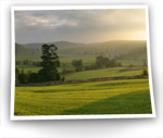
Take the track signposted "Byway Beggarman?s Road 5 1/2 miles", this is the Cam High Road. Continue uphill for views of Wensleydale. After 2 miles (3.22km), turn left along the tarmac road.
You will reach a stile and signpost "F.P. Countersett". Go through the gate and walk to Countersett with views of Semer water and Raydale.
Join the tarmac road signposted "Stalling Busk 1 1/4 miles" and go downhill to the shore of Semerwater. Head back to road bridge.
Take the path, signposted "Footpath Bainbridge 2 miles". Follow it along the banks of the River Bain. Cross the ladder stile and head for the stile and signpost at the top corner of the field. Go through the stile. Continue on the well-defined path to the top of the hill in front of you.
Continue downhill to the stile and main road. Turn left and return to the village.
Castle Bolton Circular Walk
Distance: 11 miles (17.70km)
Leave Castle Bolton and walk westerly through pleasant Wensleydale pastureland - sheep and stone walls - until you reach Ivy Scar beneath which there is a chance to look at the Bronze Age stone circles and Wet Groves Iead mine.
Past Disher Force and its old pump, you drop into the picturesque hamlet of Woodhall and then onto the River Ure.
Following the river downstream and onward to Avsgarth Falls. and the National Park Centre.
After the walk up to Hollins Farm across to Thoresby Lane and down Watery Lane to the stepping stones across the River Ure - Slapestones Wath. From here we follow the permissive path to Redmire, recently developed by Bolton Estates. Past Redmire Force over the steel girder bridge across Apedale Beck and onto Redmire and its old propped up oak tree. Then follow field paths up to Bolton Castle.
Hawes Circular Walk
From the Dales Countryside Museum at Hawes, walk up to the main road where you turn left and follow the A684 out of the town. Just before the last houses on your right take the footpath to the right through a kissing gate (signpost ?Burtersett?). Follow the flagged path straight on to reach a lane. Cross over the road and take the path opposite to the left and follow the clear path straight on, bearing slightly to the left, through a small wall gate, after which continue along the stone-flagged path across several fields through a series of wall gaps. As you approach the houses of Burtersett, the flagged path divides ? follow the right-hand path that leads uphill and on between the houses into Burtersett.
Turn right and follow the road up through the village then where the road bends round to the left take the lane to the right (?Dead End? sign). Walk along this lane then after a short distance take the rough track to the left (signpost). Follow this clear track out of Burtersett and continue to follow it as it climbs steeply up, bearing to the right across the flanks of Wether Fell. Follow the clear track up passing through two gates then up and round to the left to pass between Yorburgh on your left and Wether Fell to your right. The track levels out and becomes a grassy track that leads down to a gap in the stone wall across your path near to a small hut. Head through this wall gap then, almost immediately, where the track bends sharply to the right head straight on across the grassy moorland and follow the clear narrow path up, across a tumbledown wall and on to reach the walled track of Cam High Road (Roman Road).
Turn left along Cam High Road and follow this straight on downhill for 3 miles (crossing a road across your path after 1½ miles (2.41km)) to eventually join a metalled lane, which you follow straight on down into Bainbridge. As you walk into the village head to the left across the village green to reach the Rose & Crown pub.
Leave Bainbridge along the road to the right of the Rose & Crown pub (?Askrigg?) and follow this road down to Yore Bridge across the River Ure. Immediately after the bridge take the footpath to the left (signpost), after which bear up to the right through a kissing gate then head straight on over the old railway line to pass to the right of the farm buildings ahead. Head through a gate just after the farmhouse then walk behind the farmhouse and on to quickly join the road through another small gate beside the main farm entrance. Turn left along the road then take the footpath to the right after about 200 yards (signpost ?Skell Gill?). Head straight on across the field to reach the wall opposite, however turn left here alongside the stone wall (do not head through the gate). Where this wall bends round to the right, head up to the left to a wall-gap, after which head to the right and walk over the small hill alongside the overgrown hedge / tumbledown wall on your right to another wall-gap. After this wall-gap bear to the right down across the hillside, through a wall-gap in the stone wall across your path (in the stone wall which is heading down the hillside ? farmhouse across to your right). After this, head on to join a lane near to a stone barn.
Turn right along the lane, bending round to the left passing the farmhouse climbing up the hillside to reach a gate. After the gate continue along the track as it bends round to the right (alongside the stone wall on your right) and levels out ? at the signpost (?Sedbusk?) turn off to the left away from the clear track across the grassy moorland and drop down to join a clearer grassy track alongside a stone wall on your left. Follow this track, becoming much clearer, straight on passing a number of farmhouses until you eventually join a clear track that passes behind a large double gable-ended farmhouse.
Head straight on along the clear track passing the farm buildings and through a gate after which continue straight on along the grassy track again alongside the stone wall on your left. The track heads on through a series of gates and then becomes a very clear enclosed track, then after a short distance before this track bends round to the left take the footpath to the right over stone steps beside a gate. Turn left after these steps and walk straight on across the field, keeping close to the wall on your left, over a stream to reach a wall-gate, after which head straight on following the clear path through a series of wall-gates on to reach the houses at Litherskew. As you reach the lane at Litherskew walk straight on along the track for a short distance then where this track divides take the left-hand branch (signpost) passing between the farm buildings to reach a gate just after the barn on your right (ignore gate and track to the left). After the gate, head straight on through a wall gate ahead and continue on across a series of fields through wall gaps ? as you approach the houses follow the path bearing very slightly to the left straight on that leads into a small copse of woodland. Walk through the woods then where you emerge from the woods continue straight on alongside the wall on your right to a wall-gate ahead that leads on to reach a lane at Sedbusk.
Turn left along the lane down out of Sedbusk then, after a short distance, take the footpath to the right (where the road opens out slightly) through a small wall-gate. Bear to the right down across the field, through a wall-gate then continue on dropping down to join the road through another small wall-gate. At the road take the path opposite to the right (signpost ?Haylands Bridge?) and follow the clear path bearing to the right down across the field, over a stone bridge and on to reach the road. Turn left along the road, over Haylands Bridge and follow the road round to the left back up to Hawes ? a flagged path to the right cuts off a corner of this road.
Hawes to Hardraw Force Circular Walk
Distance: 5 miles (8.05km)
From Hawes leave the car park by crossing the disused railway line. Pass through the gate to join the road. Turn right, taking a footpath on your left signposted ?Pennine Way? and cross the field along a paved path.
Rejoin the road and follow it over the River Ure. Ignoring the path signposted to Hardraw, climb the hill to a Pennine Way sign on the left above the tree
Take the path over stiles and through pastures, with a fine view of Wensleydale, entering Hardraw opposite the Green Dragon Inn.
The name Hardraw comes from the Old English and means ?the Shepherd?s dwelling?. The church was rebuilt in 1680 by the Earl of Wharncliffe.
Pass through the inn itself (fee payable), taking the main path into the wooded gorge. The impressive drop of Hardraw Force comes into view.
With an impressive drop of 96 feet, Hardraw Force is the highest above-ground, single drop waterfall in England. The acoustics of the natural amphitheatre are so good that an annual band contest, begun in the 1880?s, has now been revived and takes place every September; surely one of the finest settings in Great Britain.
Retrace your steps back through the public house then turn left and take the steps on the left of the inn. Cross a stile and follow the uphill path. Climb the field to a stile and join a farm track which takes you to a road. Turn left and, where the road bends right, go straight ahead to join a walled path leading to a footbridge.
To explore the wooded stream above Hardraw Force, cross and follow the path upstream, recrossing at another footbridge. Once over, return to the first bridge and then the road. Follow the road to the hamlet of Simonstone.
Simonstone Hall Hotel is a splendid building, with glorious views over Wensleydale. It was built in 1733 and was originally the country home of the Earl of Wharncliffe, but has been a high class hotel for a number of years.
Proceed past the hotel to pass through a stile on the left just past a farm entrance. The path follows a straight line through several fields and over stiles towards Sedbusk. Two fields short of Sedbusk the path descends right, to a stile leading on to the road.
Cross the road to enter the next field through a stile and descend through further stiles to another lane. Again, cross into the next field and bear right, crossing a stile and an old footbridge. Follow the path to join the main road, turning left to cross the bridge.
Continue ahead, and re-trace your footsteps to the starting point in the old station yard. The arrival of the railway in 1877 brought the first tourists to this station; however in 1965 the track was removed. The Dales Countryside Museum and the National Park Centre which are both worth a visit.
Mossdale and Cotterdale Walk
Starting from the sleepy village of Appersett, this walk visits two secluded valleys at the head of Wensleydale. The walking is easy and the views of the surrounding fells are impressive.
Mossdale is Wensleydale's smallest side valley, stretching from Appersett to the Mossdale viaduct. Appersett, lying in a sheltered position below the slopes of Widdale Fell, is a peaceful village with most of its cottages facing away from the main road. The green, enclosed between the road and Widdale Beck, is often crowded with ducks, geese, goats and children.
The road from the village is followed over Widdale Beck to New Bridge, where a stile descends to the bank of the river Ure. The path leads through pastures, woodland and meadows to the farm road near Birk Rigg Farm.
From here a detour to visit the most attractive waterfall of Cotter Force is highly recommended. A short and easy stroll along the tree-lined Cotterdale Beck leads to the secluded waterfall, which cascades over a series of limestone ledges on its way to join the river Ure further downstream.
After returning from the falls, the route leads back to the river, and then continues to Mossdale Head. The four-arched viaduct, crossing the ravine of Mossdale Beck, once carried a branch line of the Wensleydale Railway from Hawes to the Settle and Carlisle line link at Garsdale Head.
The area around here is much more peaceful now with only the cascading waterfalls of Mossdale Beck framed by the backdrop of the viaduct arches. The beck rises on Widdale Fell, whose summit stands at 2,203 feet and is called Great Knoutberry Hill.
At Thwaite Bridge a steep path leads up through a wood and over the ridge of Cotter End into Cotterdale. During the crossing of this ridge some of the finest views of the walk are to be seen. Lunds Fell to the west and Great Shunner Fell to the east rise up from this peaceful and secluded side valley.
Cotterdale, 'The valley with the huts,' is also the name taken by the lovely hamlet at the head of the valley. Being situated at the end of a narrow lane.
The route from Cotterdale traverses the lower slopes of Great Shunner Fell, with exceptional views of Cotterdale and Wensleydale. To the south Wether Fell, Dodd Fell and Widdale Fell dominate the landscape. Cotter End lies to the west and winding its way through the valley bottom is Cotterdale Beck.
After crossing Bluebell Hill, a section of the Pennine Way is followed before descending through the fields and returning to Appersett.
Semerwater Circular Walk
Distance: 3.74 miles (6km)
Leave your car on the foreshore parking area and set off on the road in a southerly direction. Opposite Low Blean farm, take the footpath due south, towards Stalling Busk. Please keep in single file across the meadowland. The footpath passes through Semerwater Nature Reserve, managed by the Yorkshire Wildlife Trust. Semerwater is not only important for birds, but plankton, mayflies and crayfish. The path continues onto the ruins of the old chapel of Stalling Busk. This was built in 1772, please take care if you look around the graveyard area. Head towards Marsett, using the footbridges to cross over Cragdale Water and Raydale Beck. Once in Marsett, there are two choices of return. The shortest route is back along Marsett Lane, cutting the corner off, using a footpath 400m before Countersett. It's a short walk over Semerwater Bridge back to the foreshore. If the weather's fine (it is sometimes!) it's worth the effort required getting up onto the fell top above Marsett. Follow the path towards Knights Close, but turn off to the right after 300m. This path leads up through the Cow Pasture, linking with the bridleway on the tops. Follow the bridleway east eventually joining Crag Side Road. Look for buzzards around here! Drop down the road, skirting past Countersett and over Semerwater Bridge (first built by the Quakers) and back to the parking area.
